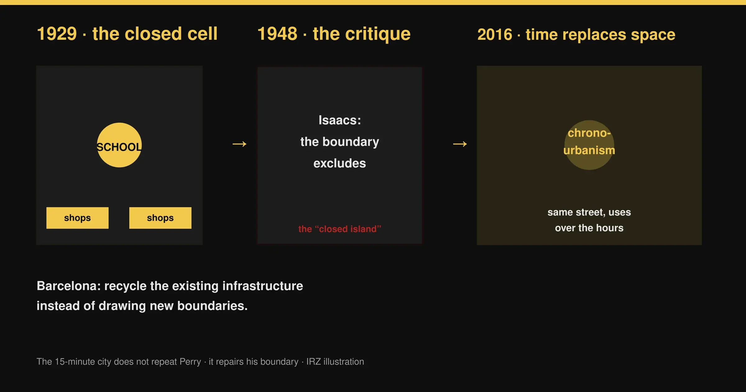
The 15-minute city was not invented in 2016. Carlos Moreno formalized it and pushed it onto the global agenda that year, true. But the idea that daily life can — and should — unfold within walking distance has a far older ancestor, and industrial designers have not missed it: on 27 August 2026, designboom reminded readers that Clarence Perry organized exactly that promise in 1929, under the name “neighborhood unit,” inside the Regional Plan of New York and Its Environs.1
That historiographical reminder lands at a useful moment, but it hides a more interesting editorial story than simple lineage. Contrary to what designboom’s headline suggests, the 15-minute city is not the repetition of an old idea. It is a repair. It takes up the problem Perry posed — bring the essentials closer to home — but it corrects the part that broke a century earlier: the rigid spatial boundary and the physical determinism that came with it.
What Perry actually drew
You have to be precise about what the original source actually says, because contemporary revivals blur it. The neighborhood unit is not simply a “walkable neighborhood.” It is a spatial cell with codified dimensions, designed as a self-sufficient system inside the metropolis.
Perry proposes roughly 5,000 to 6,000 residents — enough to feed an elementary school of 1,000 to 1,200 pupils. That school sits at the geometric center: it is the civic heart of the neighborhood, around which community facilities, recreation areas and open space radiate. The cell covers about 160 acres, or 65 hectares, and fixes a walking distance of a quarter to half a mile between the residential perimeter and the central facilities. Parks and playgrounds are meant to occupy about 10 percent of the unit.12
Circulation is designed by elimination. Arterial roads carry regional and through traffic around the neighborhood; inside, curving streets and cul-de-sacs discourage transit and create a quiet environment for domestic life and children’s play. Shops are concentrated at the edge, where they can serve residents via interior streets while staying connected to main routes.1
The masterstroke — the piece that makes the model more than a pleasant district — is the reciprocal relationship between boundaries and functions: the school is the school, the park is the park, commerce lives at the edge. Every space has a stable function, and the boundary protects what the cell contains. That architecture, not simple proximity, is the source of its power and later its failure.
Perry invented none of his principles from nothing. He was influenced by his observation of Forest Hills Gardens (Queens), a planned community drawn by Frederick Law Olmsted Jr. and supported by the Russell Sage Foundation, where he found a model for organizing residential life around shared spaces. In the same year, 1929, Clarence Stein and Henry Wright translated several of these ideas into built form at Radburn (New Jersey): its superblock separates pedestrian and automobile circulation and places a continuous interior park within the residential fabric.1
The cell that claimed to produce social bonds
The neighborhood unit is transferable — and therefore interesting for IRZ — because of the mechanism it assumes, rather than because of its drawing: the conviction that physical arrangement can produce a social effect. That is exactly what planning historian Larry Lloyd Lawhon dissected at length in 2009 in the Journal of Planning History: the neighborhood unit rests on a form of physical determinism, the belief that spatial layout can help engineer social relationships and recreate the intimacy of small communities within the industrial metropolis.3
Yet Lawhon warns against too harsh a reading. After tracing the institutional, social and design forces that shaped Perry, he concludes that the neighborhood unit, “while having social influences in residential life, is more accurately termed a physical design model that weaves neighborhood layout and opportunities for interaction.” In other words, the model weaves a potential, not a guarantee. The plan and the promise should not be confused.3
That nuance has often been crushed in public debate, and the primary sources allow us to restore it. They also let us see the explicit limits of the model. The 1929 critical edition notes that Perry sought to create “functional, safe, and attractive communities for middle- and upper-income nuclear families with children” — and that he paid little attention to households without children or to communities defined by race, ethnicity or sexual orientation.2 This is not an anecdotal detail: it is the key to the failure that followed.
The first failure: when the boundary protects some and excludes others
The sharpest critiques arrive at the end of the 1940s, when Reginald Isaacs, then director of planning for the Michael Reese Hospital in Chicago, attacks the model head-on. The American Planning Association’s PAS Report 141 preserves the core of the controversy. Isaacs rebels against what he sees as near-unanimous endorsement of the neighborhood unit as a panacea for urban ills; and above all, his critique is double-edged: the unit is presented either as a nostalgic return to rural life, or as an instrument of segregation.4
On the second point, the text leaves no ambiguity: the neighborhood unit, writes Isaacs, is used as “an instrument for the segregation of racial, ethnic, religious, and economic groups,” a neighborhood described as a “tight little island” devoted as strongly to keeping out “undesirable” people as to restricting through traffic.4 The exact articles are documented: “Are Urban Neighborhoods Possible?” (Journal of Housing, July 1948) and above all “The ‘Neighborhood Unit’ is an Instrument for Segregation” (Journal of Housing, August 1948), as well as “The Neighborhood Theory — An Analysis of Its Adequacy” (Journal of the American Institute of Planners, Spring 1948).4
The reaction is immediate. Lewis Mumford rises to Perry’s defense and disputes that the neighborhood principle has anything to do with segregation by race or income.4 But even contemporaries who reject Isaacs’s conclusions concede the strength of his documentation; some confine the problem to a “misuse” of the concept rather than an intrinsic vice.4
The most telling verdict comes retrospectively from Jane Jacobs. In The Death and Life of Great American Cities (1961), she does not merely undermine the boundary: she attacks its very principle. For Jacobs, urban safety and vitality grow out of active streets, mixed uses, dense networks and continuous pedestrian presence — they do not come from insulating residential areas from activity. The city works through permeability — “eyes on the street” — not through protection by separation.1
The lesson, very IRZ, is right here: the boundary designed to protect — the school, the child, the quiet — also served to exclude. The spatial container, with its fixed functions, turned a social aspiration into an instrument of sorting. That is the part a century of practice revealed as broken.
The repair: replace space with time
This is where Carlos Moreno’s 15-minute city becomes something other than a rediscovery. Moreno, a professor at Université Paris 1 Panthéon-Sorbonne, began formalizing his thinking in the run-up to COP21; the reference piece, “La ville du quart d’heure : pour un nouveau chrono-urbanisme,” appeared in La Tribune on 5 October 2016.5
The point of rupture is conceptual. Perry reasons in space: acres, population, a street hierarchy, a walking distance. Moreno shifts the measure toward time: urban quality of life, he writes, is inversely proportional to the time spent in transport — especially by car. Hence the central term, chrono-urbanism, and the idea of a city “in continuous time,” multi-rhythmed, where the sequential boundary between the working day city and the night city erodes.56
The framework, formalized in detail in 2021 in the journal Smart Cities by Moreno with Zaheer Allam, Didier Chabaud, Catherine Gall and Florent Pratlong, rests on four components — proximity, diversity, density, ubiquity — and promises six essential functions reachable within fifteen minutes on foot or by bike: living, working, commerce, healthcare, education and entertainment.6
The decisive difference from Perry lies in the temporal flexibility of places. The neighborhood unit assigns stable functions in space: the school is the school, the park is the park, commerce lives at the edge. Chrono-urbanism asks how the same infrastructure can carry different uses at different times: the schoolyard becomes a public space outside school hours, the street oscillates between vehicles, pedestrians, dining and events, civic buildings host cultural uses after their working day.16
The four components deserve closer attention, because they are the direct descendant — and correction — of Perry’s assumptions. Proximity replaces the object-distance of the 1929 cell: instead of drawing a perimeter, the goal is to guarantee that from one’s home, the essential functions are reachable.6 Density is no longer a number of storeys but a density of people per square kilometer, high enough to sustain local shops and services without relying on the car — a threshold Perry set arbitrarily around an elementary school’s catchment.6 Diversity is double: mixed uses and mixed people, where the 1929 model assumed homogeneous neighborhoods of middle-class nuclear families.26 Finally, ubiquity responds directly to the failure of the boundary: it is not enough for proximity to exist, it must be spread across the city and open to all — not reserved for a few privileged islands.56
The concept imposed itself well beyond the page. The 2021 text documents its adoption in Anne Hidalgo’s municipal campaign in Paris (“Paris en Commun”), won in June 2020, then its uptake by organizations such as C40, the WHO, UN-Habitat and the OECD.6 The granularity of the promise changed: the 15-minute city aims at a polycentric network in which several neighborhoods contain overlapping combinations of functions, rather than at perfectly autonomous communities.1
Recycling in the literal sense: Barcelona’s superblocks
If the shift from the cell to duration sounds abstract, Barcelona gives it a concrete incarnation — and it may be the most important piece of this story for an IRZ audience, because it touches the reuse of what already exists.
The superblocks (superilles) model was theorized by Salvador Rueda, first within Barcelona’s Urban Ecology Agency. The logic is simple: instead of building new neighborhoods, one recycles the existing road infrastructure. Rueda says it explicitly: the superblocks project “is an urban recycling project.” 7
A superblock is a cell of about 400 by 400 meters (16 to 20 hectares), or nine city blocks in the case of the Eixample. The perimeter roads carry through traffic at a maximum of 50 km/h; the interior streets are dropped to 10 or 20 km/h, speeds that allow shared use. The result is that more than 70 percent of the space currently occupied by through traffic is freed for walking and cycling, without demolishing a single building. Rueda presents the city-wide rollout as “the largest recycling project in the world.” 7
The documented numbers are striking precisely because they show the efficiency of reuse rather than new construction: networking the superblocks cuts the length of through-traffic streets by 61 percent, and a reduction of about 13 percent in vehicles is enough to maintain a comparable level of service. Each cell hosts, on average, more than 6,000 inhabitants — Perry’s neighborhood-unit order of magnitude, but without the grassroots drawing that came with it.78
The Poblenou pilot (2016), staged during European Mobility Week with a tactical-urbanism approach, tested the model within an existing, densely built fabric.8 It is the most direct answer to Perry’s philosophical problem: the 15-minute city takes shape by reallocating — temporally and functionally — what is already there, instead of drawing new limits on empty land. The same street becomes, over the course of day and week, circulation, square, market, playground.
The return of the repressed
The story does not end there, and that is precisely what makes the comparison with Perry so instructive. For the piece Moreno removed — the spatial boundary — ended up resurfacing in another form: the debate around the 15-minute city itself got caught, a century after the one that had struck the neighborhood unit, in a controversy about confinement and exclusion.
The tipping point is well documented from 2023 on. The BBC tells how Oxford, England, became the epicenter of a media storm after the county council approved a scheme of traffic filters to limit driving across the city center at peak times. Fringe outlets described the measure as a “climate lockdown”; theories circulated that residents would be “locked in” their districts, “stripped” of the right to move. Local councillors received threatening messages, including transport officer Duncan Enright, and protesters marched through Oxford in February 2023 against “15-minute cities.” 10
England’s transport secretary, Mark Harper, announced at the Conservative conference that he wanted to “call time on the misuse of so-called ‘15-minute cities’.” Carlos Moreno replied that “associating the ‘15-minute city’ with liberty-restricting measures is tantamount to aligning with the most radical and anti-democratic elements.” 10 The affair illustrates a mechanism well identified by researchers: post-COVID conspiracy theories projected onto city planning a “social control” reading grid.9
And here is the historical knot: this debate reproduces, almost word for word, the one of 1948. When the PAS Report 141 summarizes Isaacs’s critique, it uses exactly the same vocabulary of the “closed island” and the “instrument of segregation.” 4 The researchers who decoded the post-COVID controversy note it themselves: the equity critique that “neighborhood-based planning can contribute to segregation by compartmentalizing the distribution of facilities” resurfaces, almost unchanged, a century later.9
There is a crucial difference, however, tied to the nature of the accusation. In 1948 as in 2023, the reflex is to turn the perimeter — real or supposed — into an instrument of exclusion. But researchers carefully separate conspiracy theories (little or not grounded in data) from legitimate critiques (the risk of social exclusion and gentrification, mobility justice, participation).9 The lesson they draw is ironic and profound for the story at hand: abandoning terms like “15-minute city” or “superblocks” under the pressure of criticism would amount to losing the very language needed to articulate planning visions.9 In other words, repairing Perry does not mean abandoning the idea of proximity because it can be diverted — it means keeping the model while removing the piece, the closed boundary, that enabled the diversion.
One idea, two metrics
You still have to resist the temptation to tell too clean a story: the shift from space to time does not fix everything. Proximity alone does not guarantee a better city — Perry proved that by his very failure. A neighborhood can contain a school, a park, a grocery store and local shops within walking distance and remain socially exclusive.1
The 15-minute city inherits from Perry the conviction that everyday life should not depend on long motorized journeys. It has the opportunity to reject its cellular logic: its more ambitious goal is to make essential resources broadly available while keeping strong connections between neighborhoods — rather than to create self-sufficient communities.1
The limits are real, and they concern the condition that Perry’s determinism neglected: who has access. Housing costs, zoning, infrastructure and unequal public investment determine who benefits from proximity and who is pushed beyond the boundary.1 A fifteen-minute perimeter in an expensive district does not mean the same thing as the same perimeter in an underserved one. Ubiquity — Moreno’s fourth component — is precisely the attempt to answer this: it is not enough for proximity to exist somewhere; it must be available everywhere, including for those without a motor or a platform subscription.56
There is also a material lesson that the “repair” narrative must not crush: temporal flexibility presupposes that the infrastructure already exists — a schoolyard, a street, a civic building. It does not erase the question of equipment; it only changes its temporality. If the district has neither school nor shop, there is nothing to reallocate. Chronotopia increases the capacity of what exists; it does not manufacture the thing that exists.
The boundary that disappears
The continuity between Perry and Moreno is therefore not so much proximity — important in both cases — as a shared conviction: “urban quality begins close to home.” 1 The difference lies in what happens to the boundary. Perry imagined the metropolis as a collection of carefully bounded communities; the 15-minute city proposes a network of overlapping local worlds. When the spatial boundary gives way to a temporal organization, the part that broke in 1948 — the limit become an instrument of exclusion — ceases to be the load-bearing structure of the model.
This is a story of repair and recycling, not reinvention. And like any good repair, it only makes sense because we know exactly which part broke: the closed cell that claimed to guarantee the promise, not the promise of proximity itself.